


Measured Building Surveys Delivering Detailed Plans & 3D Scans
Precision Measured Surveys Highlands
Precision Surveys. RICS Standards. Advanced Technology.
We provide high-accuracy Measured Building Surveys carried out in full accordance with the RICS Code of Measuring Practice (6th Edition, May 2015) and under RICS Terms of Contract for Measured Surveys of Land, Buildings and Utilities (3rd Edition). All drawings and data are produced to BS 1192 standards, ensuring consistency, traceability, and technical clarity for architectural, engineering, and property professionals across the Highlands.
Using Leica Geosystems RTC360 laser scanners, total stations, drone-based LiDAR and photogrammetry, we generate millimetre-accurate datasets for CAD, BIM, and 2D orthophoto 3D model deliverables.
Highland Measured Survey Deliverables
At Norelo, we deliver measured building surveys with unrivalled technical accuracy and clarity. Using Leica RTC360 laser scanners, drone photogrammetry, and total station verification, we produce detailed floor plans, roof layouts, ITZA calculations, and deviation maps, trusted by architects, developers, and commercial landlords across the UK and Ireland.
Measured Floor Plans
Detailed internal floor plans showing structural walls, partitions, doors, windows, services, levels, and annotated room names with precise measurements.
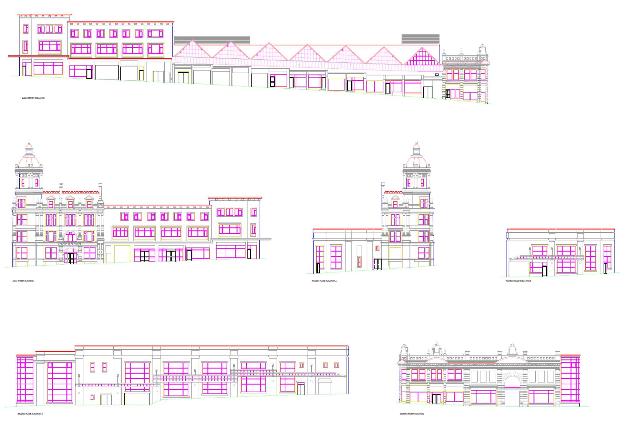
External Elevation Plans
High-resolution elevation drawings, generated from laser scan and orthophoto data, showing all architectural features, fenestration, materials and level lines.
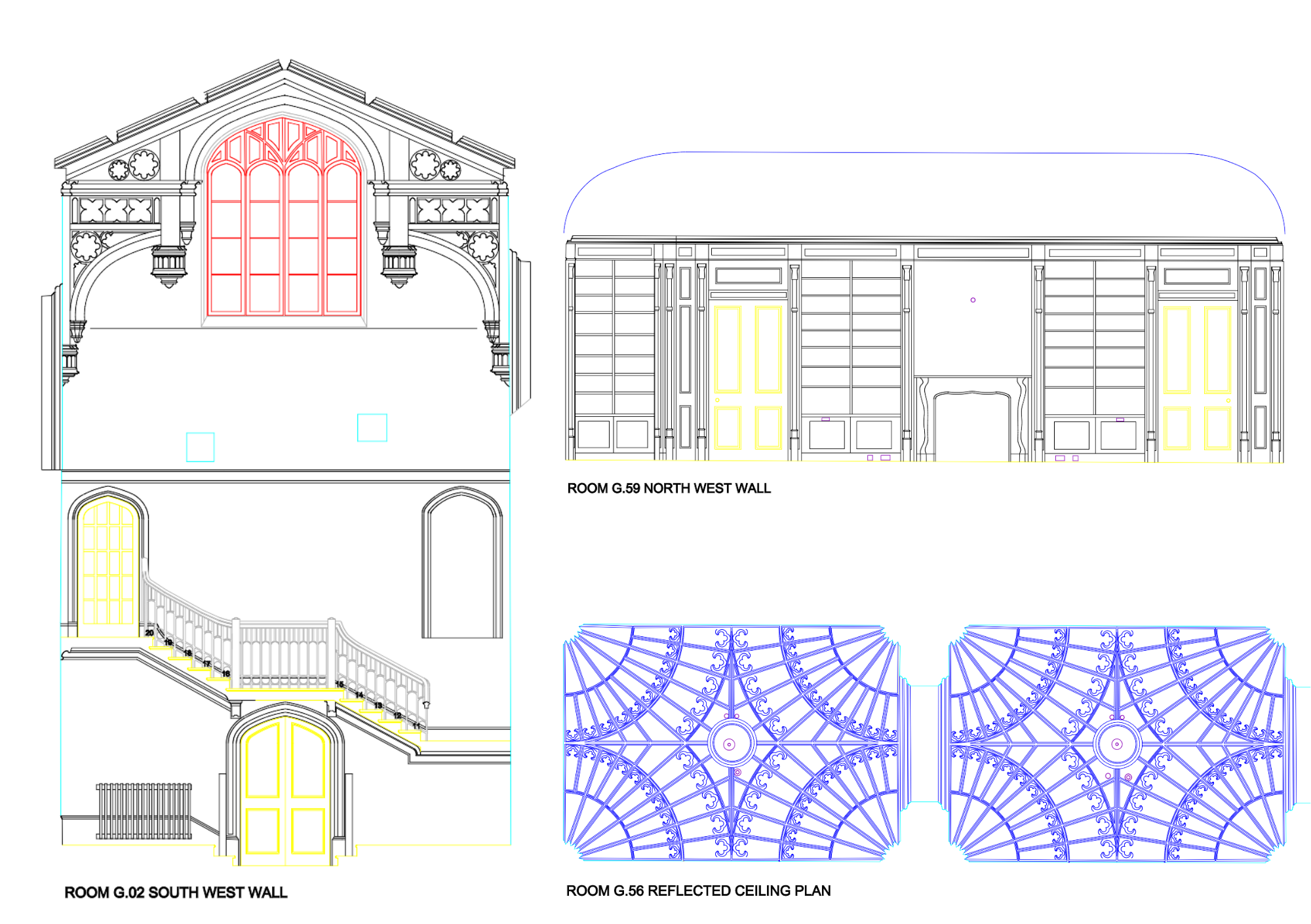
Internal Room Elevations
Detailed vertical drawings of interior walls, capturing features such as skirting, sockets, services, and bespoke finishes, ideal for joinery and fit-out planning.
Reflective Ceiling Plans (RCP)
Ceiling layouts showing bulkheads, lighting, HVAC, sprinkler heads and ceiling grids, constructed from point-cloud and orthophoto data.
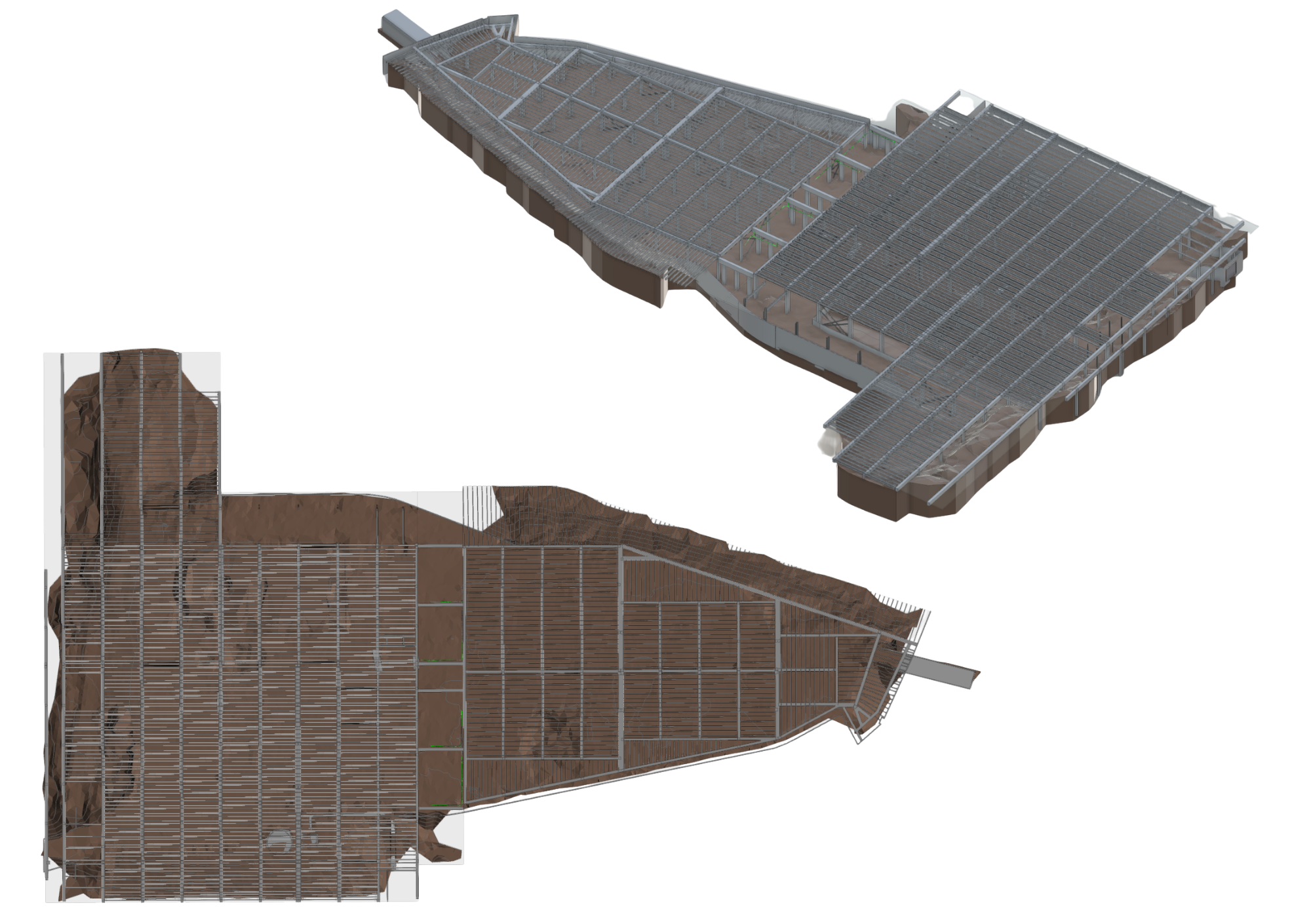
Detailed Roof Plans
Plans and slope-based geometry of pitched and flat roofs including valleys, ridges, gutters, plant, and solar arrays. Drone-based photogrammetry complements inaccessible roof scanning.
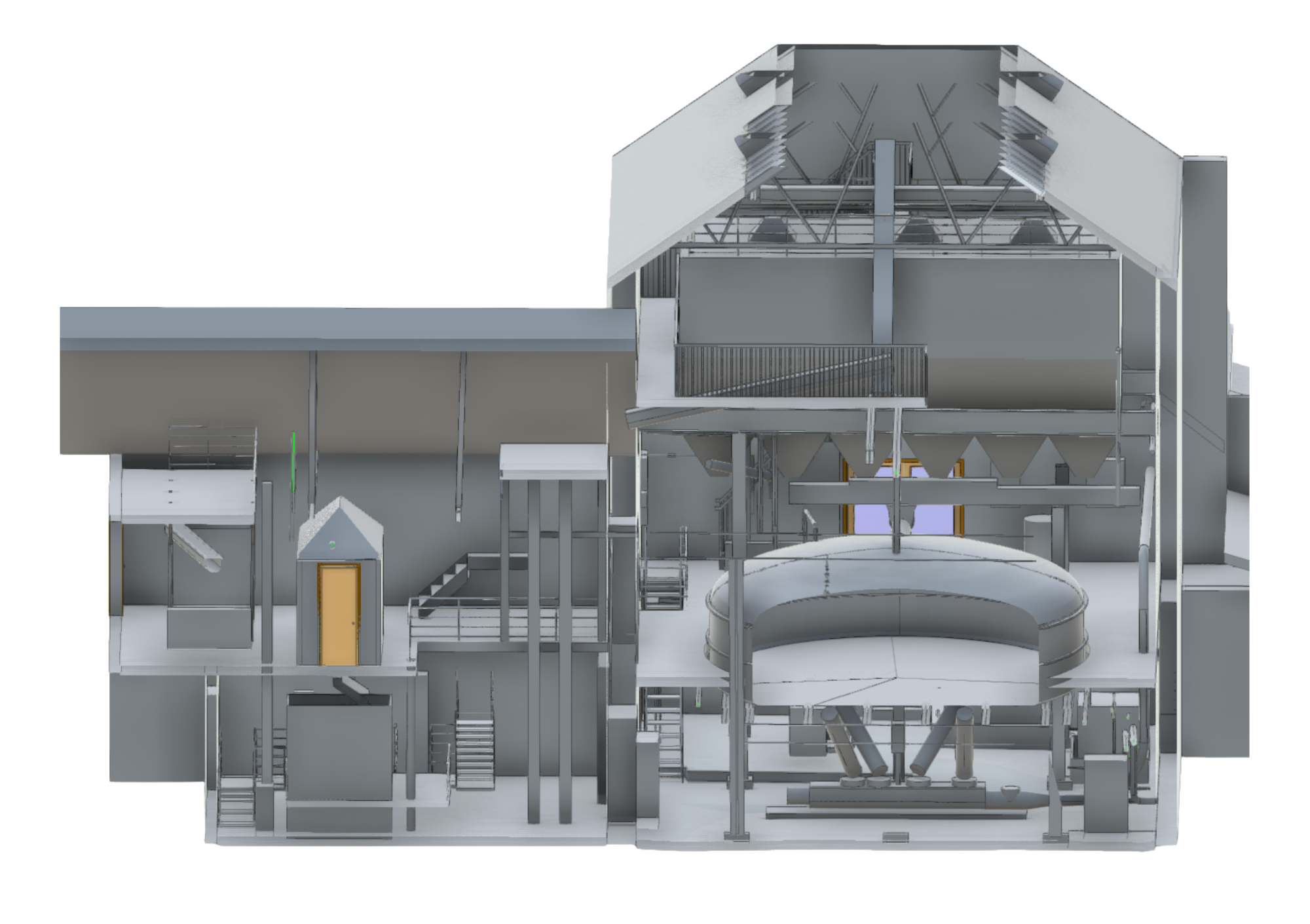
Cross Sections
Vertical slices through the building showing construction makeup, levels, voids, and structural relationships based directly on point cloud and LiDAR data.
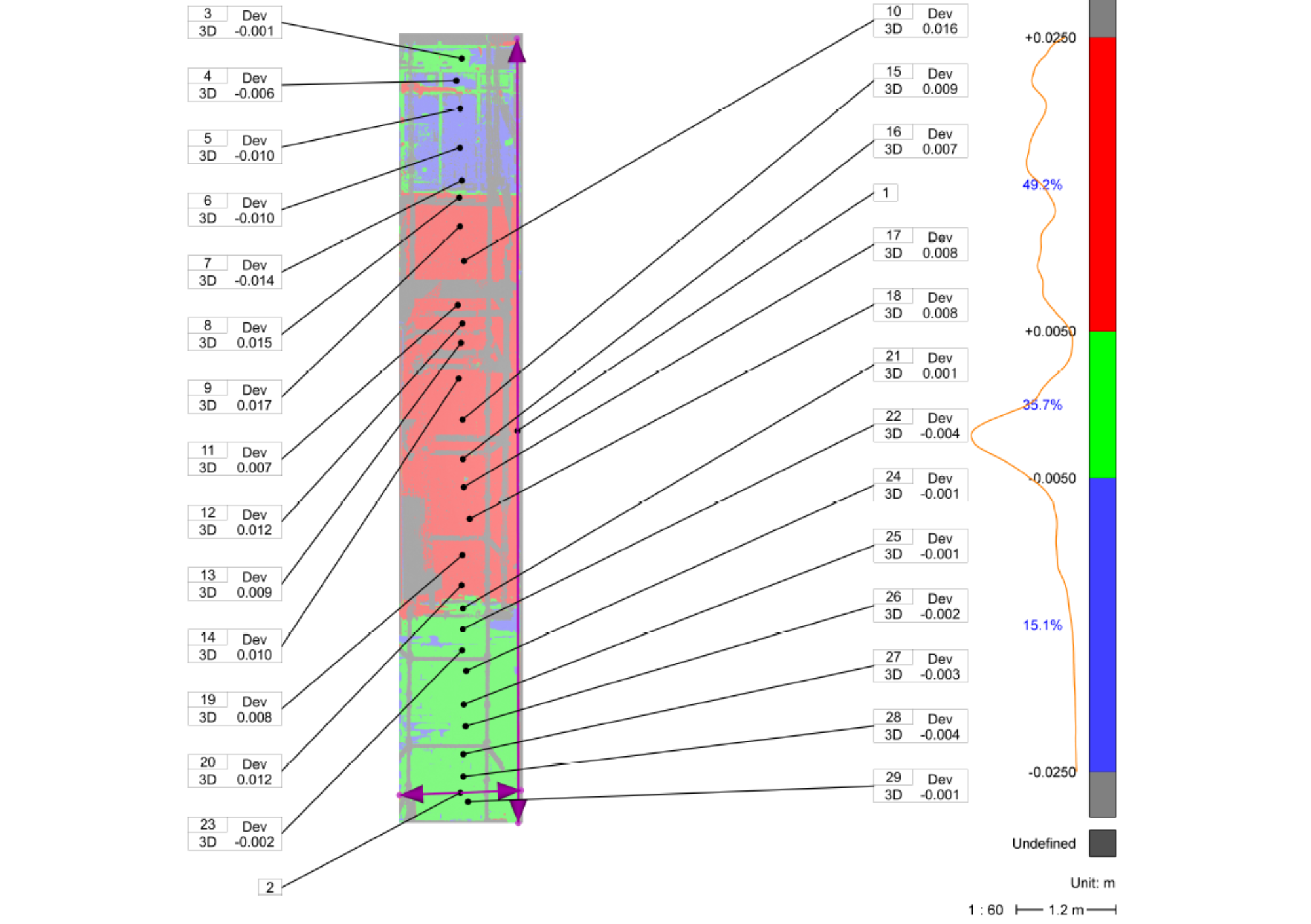
Heat Maps / Plumb & Level Analysis
Precision deviation analysis highlighting misalignments and movement. Includes colour-coded verticality maps, level surface checks, and tolerancing reports.
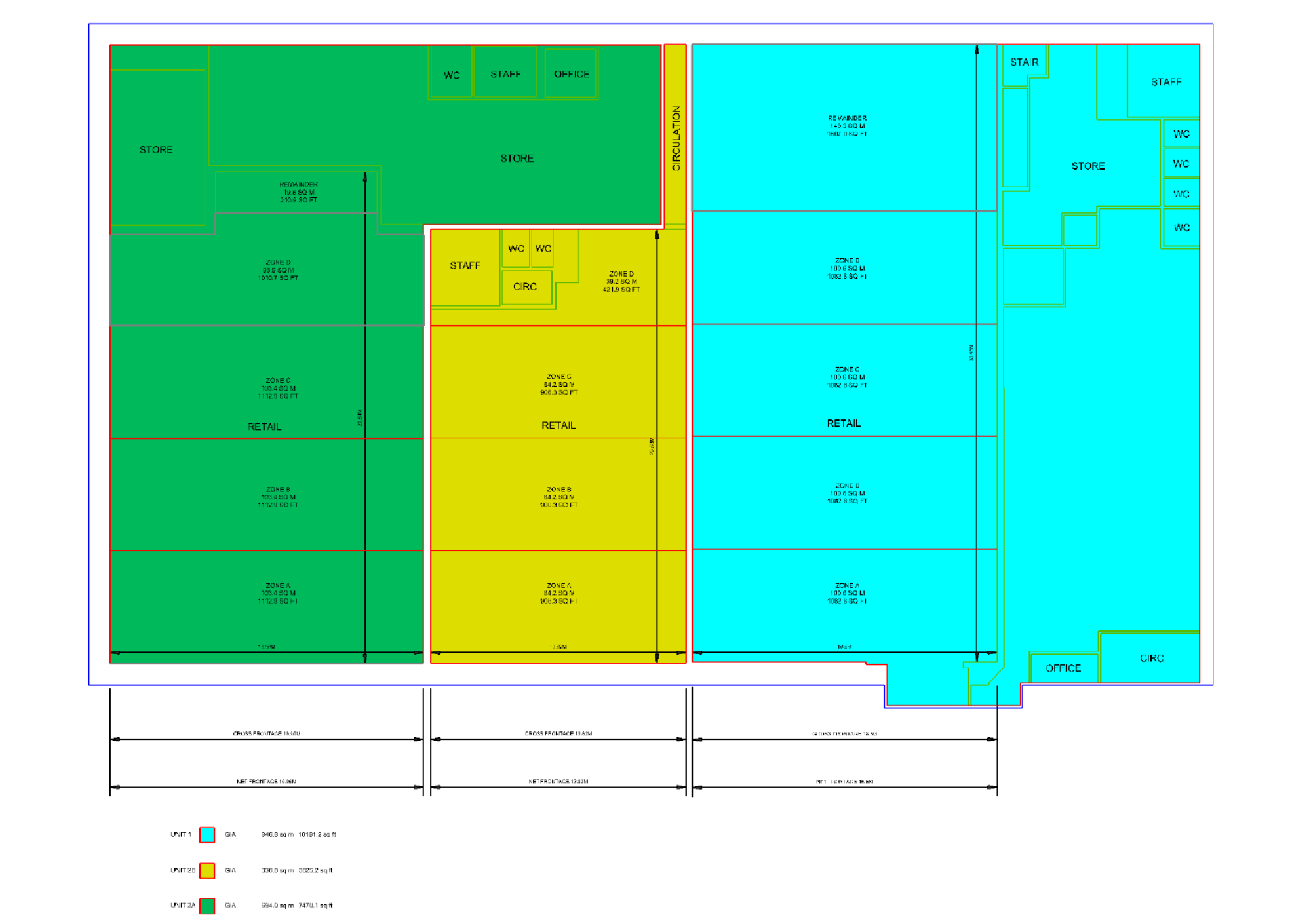
Area Calculations
All area types: Gross External Area (GEA), Gross Internal Area (GIA), Net Internal Area (NIA) and usable space derived from 3D datasets and calculated in full RICS compliance.
In Terms of Zone A (ITZA) Calculations
Retail zone measurement in accordance with IPMS and ITZA guidelines. Frontage, depth, and allocation zones defined precisely from laser scan and orthophoto data.
Tolerance Calculations & QA Reporting
Full deviation and tolerance analysis against specified limits, with supporting metadata, registration quality reports, and measurement confidence documentation.
Norelo Ltd, is dedicated to delivering cutting-edge surveying solutions across the United Kingdom. Norelo’s team of seasoned professionals combines technical expertise with innovative technology to provide accurate, high-quality data, tailored to your project requirements.
WANT TO KNOW MORE?

At Norelo, we proudly deliver measured building surveys across the entire UK and Ireland, supporting clients from city centres to rural estates. Whether your project is in Glasgow, London, Dublin, Manchester, Belfast, Aberdeen, or anywhere in between, our team of professionals deploys the latest in laser scanning, drone LiDAR, total stations, and photogrammetry to ensure consistent accuracy and quality across all locations.
Explore our full list of service areas and local measured survey pages here
AREAS WE COVER
Our Valued Clients
EQUIPMENT
Advanced Technology and Equipment
Utilising state-of-the-art equipment is at the heart of Norelo’s service delivery. Technological capabilities include:
3D Laser Scanners: For precise 3D data capture of structures and environments.
Precision GPS Total Stations: Ensuring accurate geospatial measurements and positioning.
Small Unmanned Aircraft/ Drones: Equipped with high-resolution cameras and sensors for aerial surveying.
Advanced Software Tools: Processing data into 2D CAD drawings, 3D Revit and Photogrammetry models, facilitating seamless integration into client workflows.
Why Choose Norelo?
Norelo is a trusted provider of high-precision measured surveys, known for our expertise, reliability, and use of cutting-edge technology. Our commitment to delivering accurate and actionable data helps our clients achieve successful project outcomes, whether in design, construction, or facility management.
Contact Norelo for Your Measured Survey Needs
Ready to get started with a measured survey? Contact Norelo today to discuss your project requirements or request a quote. Norelo’s team of experts is here to provide the detailed and accurate data you need to succeed.
FAQ
Measured Survey Questions
-
A measured building survey is a precise, scaled representation of a building's physical features and layout, typically including floor plans, elevations, sections, and area calculations. At Norelo, all surveys are delivered in accordance with the RICS Terms of Contract for Measured Surveys of Land, Buildings and Utilities (3rd Edition) and BS 1192 standards.
-
We use Leica RTC360 laser scanners, capable of achieving ±2 mm accuracy at a 10 m range. Survey control is reinforced with total station observations, and all deliverables are subject to strict QA processes, including registration deviation reports and tolerance audits.
-
We use a hybrid methodology comprising:
Leica RTC360 laser scanners for high-speed point cloud capture
Total stations for geospatial control and datum referencing
Drones equipped with LiDAR and photogrammetry for roof, façade, and inaccessible area capture
-
Yes. In addition to 2D CAD deliverables (DWG, PDF), we offer Revit (.RVT) and IFC outputs, structured in compliance with BS 1192 and ISO 19650. Models are developed directly from registered point cloud data for architectural accuracy.
-
Yes, we offer In Terms of Zone A (ITZA) area calculations, essential for retail valuation and lease agreements. Calculations are conducted using RICS methodology, factoring frontage, depth, and zoning, derived from high-resolution scan data.
-
Absolutely. Our scan-based methodology is ideal for historic, irregular, or ornate structures. We maintain high accuracy while preserving architectural integrity and material context, and we can tailor deliverables for conservation architects or planning applications.
-
We provide all deliverables digitally via secure client portal or cloud sharing. Formats include:
2D CAD (DWG, PDF)
3D Revit (RVT), IFC
Point clouds (E57, RCP, LAS)
QA reports and metadata logs
-
A standard measured survey includes:
Floor plans
External elevations
Cross sections
Roof plans
Area and ITZA calculations
Tolerance and plumb/level reports
We can customise the scope to suit your brief or tender.
-
Turnaround depends on building size and complexity, but most projects are delivered within 5 to 10 working days from site access. Larger or multi-building sites may require phased delivery.
-
Yes. Every project is delivered in line with:
RICS Code of Measuring Practice (6th Edition)
RICS Terms & Conditions for Measured Surveys (3rd Edition)
BS 1192 Drawing and Data Standards
We are committed to precision, accountability, and professional compliance.