Services
Drone Survey & Inspection Measured Building Survey Topographical Survey LiDAR Survey Photogrammetry CAD & Revit / BIM
The close-up your
building can’t hide from.
Norelo carries out CAA-approved drone inspections of roofs, façades, high-level stonework, cladding, bridges and infrastructure across the UK and Ireland, delivering the geolocated imagery, measurable orthophotos and annotated reports that building surveyors, insurers, architects and engineers base real decisions on.
What a drone inspection gives you
A drone inspection puts a stabilised 4K zoom camera anywhere on a building or structure, every roof slope, chimney, parapet, cornice, soffit and fixing, with nobody working at height. For building surveyors, insurers, architects and engineers, that means full-coverage, geolocated condition evidence captured in hours, at a fraction of the cost of scaffold, MEWPs or rope access, and because Norelo is a geospatial survey practice, the imagery can be turned into scaled orthophoto elevations and measurable 3D context when your assessment needs dimensions, not just photographs.

Roofs, façades, structures, anything at height
One CAA-authorised flight team for every high-level asset, visual and zoom payloads matched to the inspection, from a single dwelling roof to a motorway bridge.
Drone roof inspections
Close-up condition inspection of pitched and flat roofs, coverings, flashings, chimneys, valleys, rainwater goods, fascias and soffits, on domestic, commercial and industrial buildings, with no scaffold or roof access.
- Pre-acquisition & dilapidations
- Storm & insurance damage
- Planned maintenance evidence
- Solar PV feasibility
Façade & cladding inspections
Systematic elevation-by-elevation capture of façades, curtain walling, render and cladding systems, panels, fixings, sealant lines and staining, giving surveyors and engineers the visual evidence their assessments rely on.
- Cladding condition records
- Fixings & sealant checks
- Water-ingress investigation
- Elevation orthophotos to scale
High-level stonework & masonry
Sub-millimetre zoom imagery of parapets, copings, cornices, spires, chimney stacks and carved detail, ideal for conservation architects and building surveyors assessing traditional and heritage buildings beyond safe physical reach.
- Defect & decay mapping
- Falling-masonry risk checks
- Quinquennial inspections
- Pre-contract condition records
Bridges & civil infrastructure
Visual inspection support for bridges, viaducts, retaining walls, culverts and towers, soffits, bearings, joints and piers captured safely without lane closures, rope teams or under-bridge units.
- Principal-inspection support
- Soffit & bearing imagery
- Scour & masonry checks
- Defect location plans
Insurance & claims evidence
Rapid, impartial post-loss capture for insurers, loss adjusters and their surveyors, storm, fire, flood and impact damage documented in geolocated, time-stamped imagery before repairs disturb the evidence.
- Post-storm damage records
- Claim validation imagery
- Before / after comparison
- Fast nationwide mobilisation
Portfolio & framework inspections
Programme-level drone inspection for local authorities, housing associations, commercial landlords and facilities managers, hundreds of roofs and elevations captured on efficient routes, reported in a consistent format and organised in one portal.
- Local authority & public sector
- Commercial property portfolios
- Housing association stock
- Scheduled re-inspection cycles
Looking for aerial mapping rather than inspection, contours, levels, volumes or terrain? That’s covered by our topographical survey and drone LiDAR survey services, with photogrammetry handling full 3D modelling.
Reports built for professional decisions
A drone inspection is only as useful as the report on your desk. Norelo delivers organised, geolocated evidence, not a memory card of photos, structured so a building surveyor, adjuster or engineer can locate, measure and act on every defect.


Measurable evidence, not just photographs
Plenty of drone operators can take a nice photo. Norelo is a geospatial survey practice, so when your inspection needs dimensions, extents and drawings, the same flight produces scaled orthophoto elevations, defect location plans and 3D context you can measure from, all controlled and quality-checked like a survey.
Every flight legal, insured and documented
Drone regulations are our problem, not yours. We plan, permission and paper every operation so your project never carries the risk.
CAA Operational Authorisation
Norelo holds a CAA Operational Authorisation, letting our qualified remote pilots operate commercially across the UK, including many congested urban environments other operators can’t fly.
- Qualified remote pilots
- Congested-area operations
- Compliant with UK drone law
RAMS on every operation
A site-specific risk assessment and method statement is produced before any drone leaves the ground, issued to you in advance, ready for your H&S file.
- Site-specific risk assessment
- Method statements issued
- Pre-flight airspace checks
Airspace & permissions handled
Flight restriction zones, NOTAMs and stakeholder permissions, airports, rail, prisons, hospitals, are identified and secured by us as part of the job.
- FRZ & airport coordination
- Rail & infrastructure liaison
- Landowner notifications
Insured & accredited
Fully insured drone operations from a SafeContractor-approved, Cyber Essentials-certified company, so your data is handled as safely as your site.
- SafeContractor approved
- Cyber Essentials certified
- Secure data handling
From enquiry to aerial data in four steps
A disciplined drone survey workflow, scoped, permissioned, flown and processed by the same team.
Scope & flight plan
We define outputs, accuracy and coverage with you, then design the flight, altitudes, overlap, payloads and ground control layout.
Permissions & RAMS
Airspace checks, restriction-zone approvals and stakeholder permissions secured; risk assessments and method statements issued before we mobilise.
Fly & inspect
Systematic capture of every elevation, slope and detail, visual and zoom, with image quality checked on site before we demobilise.
Report & deliver
Imagery is organised, annotated and — where needed — processed into scaled elevations and 3D context, then delivered through your secure Norelo portal.
Built for the professionals who sign the report
Building surveyors, insurers and loss adjusters, architects and engineers across the UK & Ireland use Norelo drone inspections as the evidence base for their own professional assessments.

Building surveyors
Full-coverage roof and façade evidence for condition reports, dilapidations and acquisitions — white-label available.

Insurers & loss adjusters
Rapid, impartial post-loss capture — storm, fire and impact damage documented before repairs disturb the evidence.

Architects
Roof condition, scaled orthophoto elevations and 3D context for refurbishment, retrofit and conservation design.

Engineers & infrastructure
Bridge, structure and asset inspection imagery without lane closures, rope teams or possession planning.
Your aerial data, live in one portal
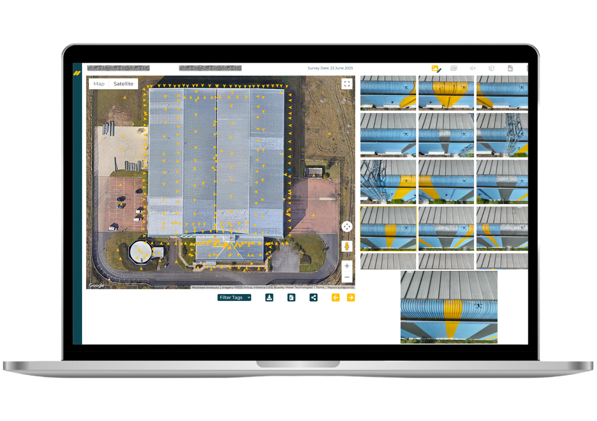
No WeTransfer links, no photo dumps. Every Norelo drone survey is delivered through your secure client portal, browse imagery by location, review defects, explore 3D models and download everything from any browser.
Drone inspection in the UK
Drone inspection has moved from novelty to standard practice across the UK’s built environment. Under the CAA’s regulatory framework, authorised operators now provide the close-up, high-level evidence that building surveyors, insurers and engineers once needed scaffolding or rope access to obtain — faster, safer and at a fraction of the cost. For professional teams, drone-first inspection is increasingly the default first step before any money is spent on access.
The UK’s building stock is particularly suited to it: large volumes of older traditionally-built property — slate and tile roofs, masonry parapets, chimney stacks and ornate stonework — where high-level defects develop out of sight and access costs have historically delayed inspection until failure.
A maritime climate does the rest. Wind-driven rain, freeze-thaw cycles and winter storms work constantly on roof coverings, flashings, mortar joints and fixings — which is why regular, affordable high-level inspection has become central to planned maintenance rather than an emergency response.
Flying legally takes more than owning a drone: much of the UK sits within flight restriction zones, conservation areas and congested urban environments where permissions, coordination and a CAA Operational Authorisation are essential. Norelo handles all of it — operating nationwide across the UK and Ireland from our Glasgow base.
Need a drone inspection anywhere in the UK or Ireland? Tell us the building and the postcode — we’ll handle the rest.
Good to know
How much does a drone roof inspection cost in the UK?
Considerably less than the access equipment it replaces — a drone inspection typically costs a fraction of scaffold, MEWP hire or rope access, with no design, permits or erection time. Pricing depends on the building, coverage and reporting level; send us the address and what you need to see and we’ll return a fixed, itemised quote, usually within one working day. See our pricing approach.
Are your drone pilots CAA approved?
Yes. Norelo holds a CAA Operational Authorisation and our remote pilots are qualified and current. Every operation is flown under documented procedures with site-specific risk assessments and method statements (RAMS) issued in advance — ready for your H&S file.
How close and how detailed can a drone inspection get?
Our stabilised zoom cameras resolve sub-millimetre detail — individual slate cracks, mortar loss, sealant failure, corroded fixings — without the aircraft going anywhere near the fabric. Every image is geolocated, so you know exactly where on the building each defect sits.
Can a drone inspection replace a surveyor’s inspection?
It’s designed to inform one, not replace it. We provide the full-coverage, close-up visual evidence; you (or your appointed surveyor or engineer) make the professional assessment. Many building surveyors use us as their eyes at height — we also work white-label through our practice-to-practice service.
Do I need scaffolding or roof access?
No — that’s the point. A drone inspection captures every roof slope, chimney, parapet and elevation with nobody working at height, no scaffold, no cherry picker and usually no disruption to the building’s occupants or the public below.
Can you inspect bridges and other infrastructure?
Yes — bridges, viaducts, retaining walls, culverts, towers and masts. Drone capture reaches soffits, bearings and piers without lane closures, under-bridge units or rope teams, and we coordinate the necessary permissions with infrastructure operators as part of the job.
Can the imagery be used for insurance claims?
Yes. Our imagery is geolocated, time-stamped and captured impartially — we’re independent of any contractor or repairer — which makes it well suited to claim validation, post-loss records and before/after comparison for insurers, loss adjusters and policyholders.
Can you fly in restricted airspace or near airports?
In most cases, yes. We identify flight restriction zones during planning and obtain approvals from airports, airfields, rail and other stakeholders before we mobilise. It’s handled by us as part of the job.
What do I actually receive after a drone inspection?
An annotated PDF report with colour-coded overviews locating every image, the full geolocated 4K image set and video, and — where your assessment needs dimensions — scaled orthophoto elevations, defect location plans in DWG and 3D context models. Everything is delivered through your secure Norelo portal.
What weather can drones fly in?
We fly within manufacturer and safety limits for wind and precipitation, and monitor forecasts closely before capture. If conditions on the day aren’t safe or would compromise image quality, we agree a prompt return visit rather than deliver substandard evidence.
Can you handle multi-site portfolios?
Yes — portfolio inspection programmes are core work for local authorities, housing associations, commercial landlords and facilities managers. Nearby sites are batched into efficient routes, outputs stay consistent across every property, and the whole programme lives in one portal login. See our property & asset managers page.
Book a drone inspection
Tell us the building or structure, what you need to see and when — we’ll confirm feasibility, permissions and a fixed quote, usually within one working day.
- 0141 353 9557
- info@norelo.uk
- 16 Royal Crescent, Glasgow, G3 7SL
- CAA-approved · SafeContractor · Cyber Essentials