Services
Drone Survey & Inspection Measured Building Survey Topographical Survey LiDAR Survey Photogrammetry CAD & Revit / BIMLiDAR surveys,
reality captured in millions of points.
Norelo captures survey-grade point clouds with Leica RTC360 terrestrial laser scanners and DJI L2/L3 aerial LiDAR on Matrice drones, registered, controlled by GNSS and TS16 total stations, and verified before delivery. One dataset that feeds BIM, drawings, analysis and as-builts, for years after the visit.
What a LiDAR survey gives you
LiDAR measures the world directly, millions of laser distance measurements a second, indoors, outdoors, day or night. The result is a registered point cloud: a complete, survey-accurate 3D record of the building, site or structure exactly as it stands. Norelo captures it with RTC360 scanners on the ground and L2/L3 payloads in the air, ties it to grid with TS16 and GNSS control, and delivers a dataset your whole team can measure, model and monitor from.
One scan, a whole project’s worth of answers
The same point cloud that draws a floor plan can verify a steel frame, model a plant room or baseline a moving wall. These are the jobs our clients put LiDAR to most.
Scan-to-BIM & measured surveys
The classic use: the point cloud becomes floor plans, elevations, sections and Revit models to agreed detail, the as-existing record every design, retrofit and refurbishment starts from.
- Revit / IFC models
- Plans & elevations
- RICS 3rd edition surveys
- Retrofit & refurb base
As-built & construction verification
Scan the works, overlay the design, and see every deviation in millimetres, steel frames, concrete, façades and MEP checked before the next trade builds on top of a problem.
- Design vs built comparison
- Frame & slab checks
- Pre-pour & pre-cover records
- Handover as-builts
Plant, industrial & MEP
Plant rooms, risers, process pipework and industrial facilities scanned in dense detail for retrofit and replacement design, new kit is modelled against reality, not against drawings from 1987.
- Plant room scans
- Pipe & services routing
- Clash-free retrofit design
- Shutdown-window capture
Deformation & structural analysis
Repeat scans and analysis surfaces reveal movement, lean, bow, settlement and deflection, with floor flatness and plumb heat maps derived from the same data.
- Movement baselines
- Lean & bow analysis
- Flatness heat maps
- Repeat monitoring
Heritage & conservation recording
Millimetre, non-contact records of listed buildings, monuments and historic fabric, an archival dataset for conservation teams, and the base for repair drawings and grant applications.
- Archival point clouds
- Repair & consent drawings
- Condition baselines
- Non-contact capture
Aerial LiDAR & land
L2/L3 payloads on our Matrice aircraft capture topographical surveys at up to 200 hectares a day, reading true ground through vegetation for DTMs, corridors and earthworks.
- Up to 200 ha / day
- Through-canopy ground
- DTM / DSM surfaces
- Volumes & corridors
Need the outputs rather than the technology? Drawn packages live on our measured building survey page, land and levels on topographical surveys, and photo-real texture on photogrammetry.
If it can be measured, LiDAR has a use for it
A registered point cloud is a general-purpose measurement of reality, which is why the use cases keep growing. If your job involves the geometry of a real place, there’s a fair chance we’ve scanned for it.
Don’t see your job? If it starts with accurate geometry, tell us what you’re trying to do and we’ll tell you if a scan solves it.

Two platforms, one standard of proof
On the ground, the Leica RTC360 captures up to two million points a second with HDR imagery at every setup. In the air, DJI L2 and L3 payloads on Matrice aircraft cover whole estates. Both feed the same discipline: TS16 total station and GNSS control, rigorous registration, and independent checkpoints before anything is delivered.
Point clouds your software already speaks
The registered cloud arrives in the open and native formats your tools expect, ready for Revit, AutoCAD, Navisworks and the rest, with derived outputs produced in-house whenever the project needs more than points.
From enquiry to point cloud in four steps
A disciplined LiDAR workflow, scoped, captured, registered and checked by the same team.
Scope & specification
We agree coverage, density, accuracy and formats, terrestrial, aerial or both, and plan setups, flights and control for the site.
Scan & fly
RTC360 setups through the building or site, L2/L3 flights where the job takes to the air, with control observed by TS16 and GNSS.
Register & verify
Scans are registered into one coordinated cloud, checked against control and independent points, and cleaned and classified for use.
Deliver & derive
The cloud is published to your portal in your formats, with drawings, models and analysis produced in-house whenever you need more than points.
The teams who work from our point clouds
Architects, surveyors, engineers and conservation teams across the UK & Ireland build their projects on Norelo LiDAR data.
Architects
Point clouds and Revit-ready data for design, retrofit and planning on real geometry.
Building surveyors
Scan data behind plans, areas and analysis, white-label capture for your practice.
Engineers & infrastructure
As-builts, verification and deformation data for structures, plant and civils.
Heritage & conservation
Archival, non-contact records of listed buildings and historic fabric.
Your point clouds, live in one portal
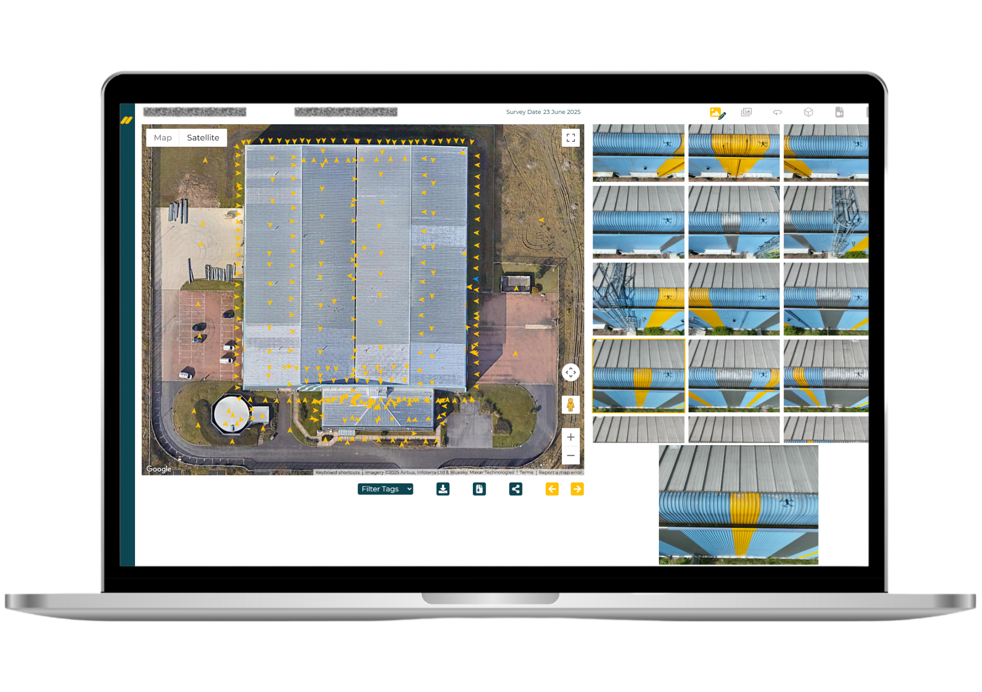
Point clouds are big; delivery shouldn’t be painful. Every Norelo LiDAR survey is delivered through your secure client portal, explore the cloud in the browser, review scan positions and imagery, and download every format from anywhere.
Good to know
What is a LiDAR survey?
A LiDAR survey measures a building, site or structure directly with laser pulses, millions of distance measurements a second, producing a point cloud: a dense, survey-accurate 3D record of reality. Norelo captures LiDAR terrestrially with Leica RTC360 scanners and aerially with DJI L2/L3 payloads on Matrice drones, registered and controlled so the data is measurable to survey standards.
What is a point cloud?
A point cloud is the raw product of laser scanning: millions of individually measured 3D points, each with a position (and usually colour), that together form a precise digital copy of the scanned scene. From it we produce floor plans, elevations, Revit models, sections, surfaces and analysis, or deliver the cloud itself for your team to work in.
What is the difference between LiDAR and photogrammetry?
LiDAR measures geometry directly with laser pulses, so it excels in low light, dense interiors, plant and vegetation, and its accuracy is independent of texture. Photogrammetry reconstructs geometry from photographs, so it wins on colour and texture resolution. They complement each other, we offer both and regularly combine them on one project.
When do you scan terrestrially and when do you fly?
Terrestrial RTC360 scanning suits buildings, interiors, plant and street-level detail, dense, millimetre-level capture from the ground. Aerial L2/L3 LiDAR suits land, roofs at scale, corridors and vegetated sites, up to 200 hectares a day. Most projects use one; plenty use both, registered into a single cloud.
How accurate is a LiDAR survey?
Millimetre-level for terrestrial scanning and survey-grade for aerial capture. Scans are tied together and to your grid through TS16 total station and GNSS control, registration is quality-checked, and results are verified against independent checkpoints, accuracy is demonstrated in the deliverables, not assumed.
What formats do you deliver point clouds in?
Whatever your workflow expects: E57 as the open standard, RCP/RCS for Revit and AutoCAD, LAS/LAZ for aerial data, PTS/PTX for legacy tools, plus meshes, DWG sections and Revit/IFC models produced in-house on request. There’s no lock-in, the data is yours in open formats.
Do I get drawings and models, or just the point cloud?
Your choice. Many clients take the cloud alone; many more have us produce the outputs in-house, floor plans, elevations, sections, Revit models, flatness and verticality analysis, so capture and drawing sit with one accountable team.
Can you scan occupied buildings?
Yes, routinely. Scanning is non-contact and quick, a whole room takes under two minutes, so offices, schools, hospitals and homes carry on around us, with out-of-hours capture available for sensitive spaces.
Can you scan plant rooms, basements and tunnels?
Yes, this is where terrestrial LiDAR earns its keep. The RTC360 works in tight, dark and complex spaces without GPS, capturing pipework, plant and structure in dense detail for retrofit design, and we plan capture around shutdown and access windows.
How much does a LiDAR survey cost?
It depends on the size and complexity of the subject, the density required and the outputs you need. Capture is fast, which keeps site costs down, and the archived cloud means future outputs don’t need a revisit. Send us the details and we’ll return a fixed, itemised quote, usually within one working day. See our pricing approach.
How long does a LiDAR survey take?
Most buildings are scanned in a day or less; large estates and aerial programmes are planned in single-day mobilisations wherever possible. Registration and QA typically complete within days, with derived drawings and models following per the agreed programme.
Is the scan data kept for future use?
Yes. The registered cloud is archived, so when the project changes, new sections, drawings, models or comparisons are produced from the existing data without another site visit, and repeat scans can be compared against the baseline for movement over time.
Book a LiDAR survey
Tell us the building, site or structure and what the data needs to do, we’ll confirm the platform, specification and a fixed quote, usually within one working day.
- 0141 353 9557
- info@norelo.uk
- 16 Royal Crescent, Glasgow, G3 7SL
- RICS-aligned · SafeContractor · Cyber Essentials