Services
Drone Survey & Inspection Measured Building Survey Topographical Survey LiDAR Survey Photogrammetry CAD & Revit / BIM
Your asset, rebuilt
in high-resolution 3D.
Norelo produces measurable, photo-real 3D models of buildings, roofs and infrastructure by photogrammetry, captured with DJI Matrice series drones and handheld cameras, controlled by surveyed ground control for real accuracy. Inspect, measure and share the whole asset from any browser.
What a photogrammetry survey gives you
Photogrammetry turns thousands of overlapping photographs into a single, high-resolution 3D model of the real asset. Norelo captures with DJI Matrice series drones for roofs, elevations and structures, and handheld cameras for interiors and detail beyond the drone’s reach, then ties everything to surveyed ground control so the finished model is measurable, not just pretty. The result: surveyors, engineers and architects can inspect, measure and annotate the entire building or structure from a desk.
Buildings, roofs, structures, in complete 3D
One capture team, aerial and handheld, for every asset that deserves more than photographs.
Buildings & façades
Complete external models of any building, every elevation, material and detail in true colour, for condition inspection, refurbishment planning, marketing and record, with scaled orthophoto elevations produced from the same model.
- Full external coverage
- Condition inspection
- Scaled elevation orthos
- Before / after records
Roof models
High-resolution roof geometry and texture without anyone leaving the ground, coverings, flashings, chimneys, plant and access routes, measurable for areas, pitches and repair extents.
- Areas & pitch measurement
- Repair scoping
- Solar PV feasibility
- No roof access needed
Infrastructure & structures
Bridges, viaducts, retaining walls, towers and industrial assets modelled in full, giving engineers a measurable, shareable record of condition without lane closures or rope access.
- Bridge & viaduct models
- Retaining walls & towers
- Defect location in 3D
- Engineer-ready outputs
Heritage & conservation recording
Millimetre-detail records of listed and historic fabric, carved stone, monuments and ruins, entirely non-contact, an archival dataset and a working model for conservation teams.
- Archival 3D records
- Carved detail capture
- Condition baselines
- Grant & funding support
Inspection & insurance models
When photographs argue, a model settles it, geolocated, time-stamped 3D capture of storm, fire and impact damage that insurers, adjusters and surveyors can inspect and measure long after repairs begin.
- Post-loss 3D records
- Measurable damage extents
- Impartial evidence
- Rapid mobilisation
Sites & progress models
Repeat photogrammetry of development sites and works in progress, compare models over time, measure stockpiles and earthworks, and keep stakeholders oriented without site visits.
- Progress comparison
- Volumes & stockpiles
- Stakeholder fly-throughs
- Scheduled recapture
Photogrammetry excels at texture and colour; where projects need dense geometric capture of interiors or complex plant, we pair or substitute it with terrestrial laser scanning, and 2D drawing packages live on our measured building survey page.
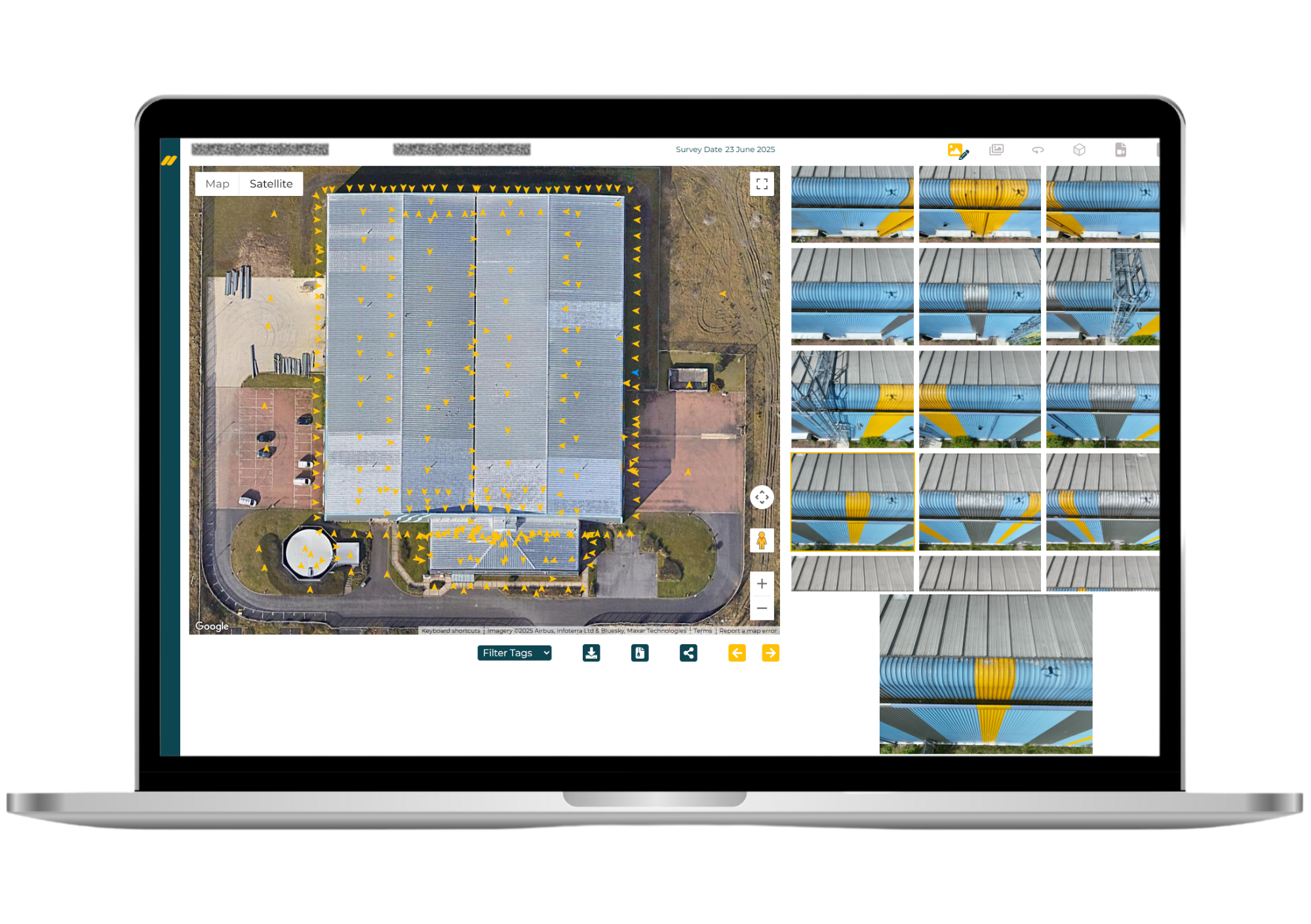
Explore live Norelo models
These are real survey models, streamed straight from our viewer. Drag to orbit, scroll to zoom, go fullscreen, this is exactly what your team receives.
Every model is delivered like this, streamed to any browser with no downloads, no plugins and no special hardware, alongside the source files for your own software.

A model you can measure, not just admire
Anyone can spin photos into a mesh. Norelo is a geospatial survey practice: every model is captured with DJI Matrice series drones and calibrated handheld cameras, tied to surveyed ground control, and verified against independent checkpoints, so the dimensions you take from it stand up in a report.
The model, and everything made from it
You receive the streamed browser model your whole team can open, plus the source data for your own software, meshes, point clouds, orthophotos and imagery, organised and hosted in your secure Norelo portal.
From enquiry to interactive model in four steps
A disciplined photogrammetry workflow, planned, permissioned, captured and processed by the same team.
Scope & flight plan
We agree resolution, accuracy and coverage, then design the capture, drone flight lines, handheld passes and the ground control layout.
Permissions & RAMS
Airspace approvals and stakeholder permissions secured under our CAA Operational Authorisation; risk assessments issued before we mobilise.
Fly, shoot & control
DJI Matrice aerial capture plus handheld photography, with ground control surveyed in by GNSS and total station, checked on site.
Process & publish
Imagery is processed into the controlled model, verified against checkpoints, and published to your browser viewer with all source files in the portal.
Built for the teams who need more than photos
Surveyors, engineers, architects and conservation teams across the UK & Ireland use Norelo photogrammetry as a measurable record of the real asset.
Building surveyors
Whole-building condition models and scaled orthos to underpin reports and dilapidations, white-label available.
Engineers & infrastructure
Measurable 3D records of bridges, walls and structures without closures or rope access.
Architects
Existing-condition models and elevation orthos for refurbishment, retrofit and planning.
Heritage & conservation
Archival-grade, non-contact 3D records of listed and historic fabric.
Your models, live in one portal
No file transfers your IT team dreads. Every Norelo photogrammetry survey is delivered through your secure client portal, open the streamed 3D model, review annotations, and download meshes, clouds and orthos from any browser.
Good to know
What is a photogrammetry survey?
A photogrammetry survey turns thousands of overlapping photographs into an accurate, high-resolution 3D model of a real asset. Software matches features across the images to reconstruct geometry, producing a photo-real textured mesh, a dense point cloud and scaled orthophotos. With surveyed ground control, the model becomes measurable to survey standards.
How accurate is photogrammetry?
With proper control, very. Norelo coordinates ground control points by GNSS and total station, processes the model against them, and verifies the result with independent checkpoints, so accuracy is demonstrated, not assumed. Typical building models are accurate to centimetre level or better, with texture detail down to sub-millimetre, and we agree the accuracy requirement with you at the scoping stage.
What is the difference between photogrammetry and LiDAR / laser scanning?
Photogrammetry reconstructs 3D geometry from photographs, so it captures true colour and texture at very high resolution, ideal for inspection, façades and heritage. LiDAR measures geometry directly with laser pulses, which excels in low light, dense interiors and complex plant. They complement each other, and Norelo offers both, see our LiDAR survey page, and often combines them on one project.
What do you capture the models with?
DJI Matrice series drones for roofs, elevations and structures, flown under our CAA Operational Authorisation, plus calibrated handheld cameras for interiors, undercrofts and detail beyond the drone’s reach. Both feed the same controlled model.
Can I measure from the 3D model?
Yes, that’s the point. Because the model is scaled and verified against surveyed ground control, you can take real dimensions, areas and extents directly from it, in the browser viewer or in your own software from the delivered mesh and point cloud.
How do I view the model? Do I need special software?
No software, no downloads. Your model is streamed to any modern browser at full resolution, on desktop, tablet or phone, through a simple share link, exactly like the live examples on this page. Source files (OBJ, FBX, glTF, LAS, E57) are also delivered for teams who want the data in their own tools.
Can photogrammetry be used for inspections?
Yes, it’s one of its strongest uses. The model gives you the entire roof, façade or structure in one measurable record: locate defects in context, measure their extent, compare captures over time, and share a link instead of a folder of photos. For close-up 4K defect imagery alongside the model, see our drone inspection service.
How much does a photogrammetry survey cost?
It depends on the size of the asset, the resolution required and the outputs you need. Capture is fast, most buildings are photographed in a single visit, and we return a fixed, itemised quote, usually within one working day. See our pricing approach.
How long does it take to produce the model?
Capture typically takes a few hours to a day on site. Processing and quality checks usually follow within days, with the browser model published first and full deliverables issued through the portal behind it. Programmes are confirmed in your quote.
Can you model listed buildings and historic monuments?
Yes, photogrammetry is completely non-contact, which makes it ideal for fragile historic fabric, and the photo-real texture records tool marks, carving and decay that geometry alone misses. See our heritage & conservation work.
Do you keep the model for future comparison?
Yes. Models and source data are archived, so a future recapture can be compared directly against the baseline, invaluable for movement, decay and repair monitoring, or a dispute long after the site has changed.
Book a photogrammetry survey
Tell us the building or structure and what the model needs to do, we’ll confirm feasibility, resolution and a fixed quote, usually within one working day.
- 0141 353 9557
- info@norelo.uk
- 16 Royal Crescent, Glasgow, G3 7SL
- CAA-approved · SafeContractor · Cyber Essentials