Services
Drone Survey & Inspection Measured Building Survey Topographical Survey LiDAR Survey Photogrammetry CAD & Revit / BIM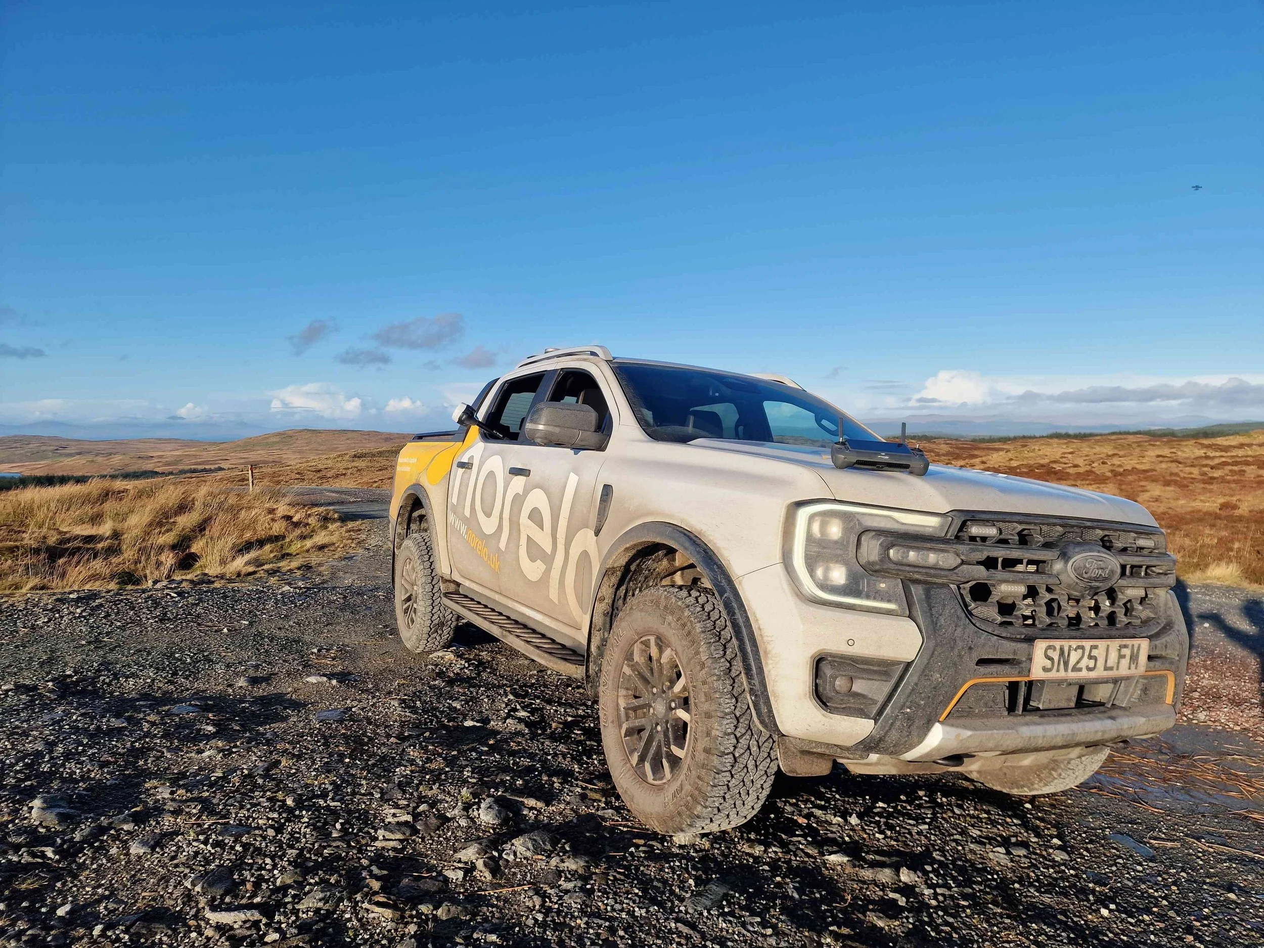
Topographical surveys,
from the air and the ground.
Norelo captures topographical surveys with the right instrument for the site: DJI L2 and L3 LiDAR on Matrice aircraft for scale, Leica TS16 total stations and RTC360 laser scanning for precision and constrained ground, and photogrammetry for crisp hard-surface detail, all controlled by GNSS and surveyed ground control. Up to 200 hectares in a day, delivered as levels, contours and CAD to OS or your site grid.
What a topographical survey gives you
A topographical survey records the shape and detail of the land, levels, contours, features, boundaries and services evidence, as the accurate base plan every design starts from. Norelo captures it with whichever method the site demands: DJI L2 and L3 LiDAR on Matrice drones for large and vegetated sites, Leica TS16 total stations and RTC360 laser scanning where precision, airspace or access call for ground methods, and photogrammetry for crisp hard-surface detail, all tied to OS or your site grid by GNSS and surveyed control.
From single plots to whole estates
One aerial capture team for every scale of site, LiDAR for the ground, photogrammetry for the detail, survey control for the accuracy.
Topographical site surveys
Complete topographical surveys of development sites, levels, contours, physical boundaries, buildings, trees, street furniture and visible services, captured by drone, total station or scanner to suit the site, and drawn to your specification on OS or site grid.
- Levels & contours
- Boundaries & features
- Visible services
- Planning-ready CAD
Large sites & rural land
Estates, farmland, forestry and moorland surveyed at up to 200 hectares a day, multi-return LiDAR reads the true ground surface beneath vegetation that would defeat photogrammetry or exhaust a ground crew.
- Up to 200 ha / day
- Through-canopy capture
- Estates & forestry
- Flood & drainage studies
Development & planning surveys
The accurate existing-site base for masterplans, planning applications and detailed design, levels, sections and constraints your architects and engineers can design against with confidence.
- Pre-planning base plans
- Site sections & profiles
- Constraint mapping
- Design-ready DTM
Roads, rail & corridors
Linear infrastructure surveyed from the air, carriageways, embankments, cuttings, verges and structures, without lane closures, possessions or boots on live infrastructure.
- Highway & rail corridors
- Embankments & cuttings
- No closures needed
- Cross sections at interval
Volumes & earthworks
Stockpile volumes, cut-and-fill balances and quarry or landfill capacity measured from the surface model, repeatable captures track movement of material over time.
- Stockpile volumes
- Cut / fill analysis
- Quarry & landfill
- Repeat monitoring
Hard-surface detail mapping
Photogrammetry flown alongside the LiDAR sharpens the surfaces that matter, kerb lines, road markings, ironwork and covers, and produces true-colour orthophotos of the whole site to scale.
- Kerbs & channel lines
- Road markings & ironwork
- Scaled orthophotos
- Colourised point cloud
Surveying the buildings as well as the land? Floor plans and elevations live on our measured building survey page, high-resolution 3D models on photogrammetry, and terrestrial scanning on LiDAR surveys.
A base plan your designers can build on
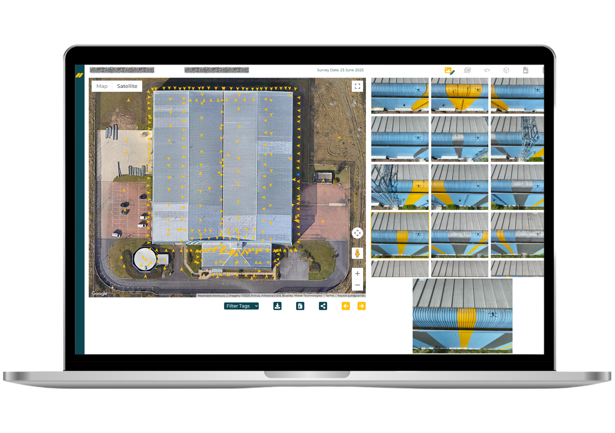
Every survey is drawn in-house to your specification and issued in the formats your design workflow expects, layered CAD, design-ready surfaces, point clouds and orthophotos, all hosted in your secure Norelo portal.

Aerial speed, survey-grade control
Flying fast means nothing if the levels are wrong. Every Norelo topographical survey is controlled like a survey: GNSS base and rover establish the control network, the TS16 total station carries it into tight corners, ground control scales and orients the LiDAR and scan data, and independent checkpoints verify the result before a single contour is drawn.
The right instrument for every site
Drone LiDAR, total station, laser scanner and photogrammetry: we carry them all, choose per site, and often combine them on one job, so the method never limits the survey.
Drone LiDAR, DJI L2 & L3
Matrice-flown LiDAR covers up to 200 hectares a day and reads the true ground through canopy, scrub and crops, the workhorse for estates, corridors and vegetated or hazardous sites.
- Up to 200 ha / day
- Through-vegetation returns
- No boots on live sites
Total station, Leica TS16
Millimetre-precision detail observed point by point, tight urban plots, boundary and kerb detail, drainage covers and critical levels, and sites where airspace rules keep drones on the ground.
- Millimetre precision
- Tight & urban plots
- Works inside FRZs
Laser scanning, Leica RTC360
Dense terrestrial scanning for streetscapes, complex level changes and sites that pair land with building surveys, millions of points from ground level, no flight required.
- Dense street-level detail
- Land + building in one dataset
- Complex levels & structures
Photogrammetry for hard surfaces
Flown alongside the LiDAR to sharpen the surfaces that matter, kerb lines, road markings and ironwork, and to produce true-colour scaled orthophotos of the whole site.
- Sharper hard detail
- Scaled orthophotos
- Colourised point cloud
From enquiry to base plan in four steps
A disciplined topographical workflow, specified, controlled, flown and drawn by the same team.
Scope & specification
We agree the survey extent, detail, contour interval and grid, choose the capture method for the site, and design the flights, instrument setups and control layout.
Control & permissions
GNSS control and check points are surveyed in, and airspace approvals, permissions and RAMS are secured under our CAA Operational Authorisation.
Capture the site
Matrice LiDAR and photogrammetry flights, with TS16 total station and RTC360 scanning wherever ground methods suit better, verified against control on site.
Process, draw & issue
The cloud is classified, the ground model built and checked, and your topographical drawing, surfaces and orthophoto issued through the secure Norelo portal.
The teams who design on our base plans
Architects, engineers, contractors and land professionals across the UK & Ireland start their sites on Norelo topographical surveys.
Architects & developers
Accurate existing-site base plans, levels and constraints for masterplans and planning applications.
Civil & structural engineers
Design-ready DTMs, sections and corridor surveys for highways, rail, utilities and drainage.
Contractors & earthworks
Volumes, cut-and-fill balances and progress surveys measured from the air, on programme.
Land, energy & renewables
Whole-estate and rural capture for solar, wind, forestry and land management at LiDAR pace.
Your site data, live in one portal
No download links that expire before the engineer opens them. Every Norelo topographical survey is delivered through your secure client portal, view the drawing, explore the point cloud and orthophoto, and download every format from any browser.
Good to know
What is a topographical survey?
A topographical survey is an accurate record of the shape and detail of a piece of land: levels, contours, physical boundaries, buildings, trees, street furniture and visible services, coordinated to a known grid. It is the base plan that architects, engineers and planners design on. Norelo captures topographical surveys by drone LiDAR, total station and laser scanning, with photogrammetry for hard surfaces, controlled by GNSS and surveyed ground control.
How much does a topographical survey cost?
It depends on the site area, terrain, vegetation and the detail specified. Aerial capture changes the economics on larger sites, a day of LiDAR flying replaces weeks of ground crew time, so per-hectare costs fall sharply as sites grow. Send us the site boundary and we’ll return a fixed, itemised quote, usually within one working day. See our pricing approach.
How large a site can you survey?
Up to 200 hectares in a single day is achievable with the L2 or L3 payload on our Matrice aircraft, and multi-day programmes cover estates and corridors far beyond that. There’s no practical lower limit either, small plots simply get surveyed very quickly.
Can LiDAR really measure the ground through trees and vegetation?
Yes. The DJI L2 and L3 are multi-return LiDAR sensors: each laser pulse can record several returns, so while the first bounces off the canopy, later returns reach the ground beneath. The cloud is then classified to separate vegetation from true ground, producing a bare-earth DTM even on sites too overgrown to walk or photograph.
How accurate is a drone LiDAR topographical survey?
Survey-grade. The aircraft flies with RTK positioning, the site is controlled by a GNSS base-and-rover network with surveyed ground control points, and the finished model is verified against independent checkpoints before drawing. Accuracy is agreed at the scoping stage and demonstrated in the deliverables, not assumed.
What coordinate system are surveys delivered in?
OSGB36 National Grid and Ordnance Datum by default, or your local site grid and datum if the project has one, agreed at the scoping stage so the survey drops straight into your design environment.
Can you survey sites where drones can’t fly?
Yes. The survey doesn’t depend on the drone: inside flight restriction zones, dense urban centres, or wherever airspace, weather or the client rules flying out, we capture with the Leica TS16 total station and RTC360 laser scanner instead, to the same specification, control and deliverables. Many of our best surveys combine air and ground methods on one site.
Why fly photogrammetry as well as LiDAR?
Because each sensor has different strengths. LiDAR measures the ground superbly, including through vegetation, while photogrammetry resolves crisp visual detail on hard surfaces: kerb lines, road markings, ironwork and covers, and produces a true-colour orthophoto of the whole site. We fly both on the same visit and fuse the results into one dataset.
What do I receive from a topographical survey?
A layered CAD topographical drawing to your specification, DTM and DSM surfaces (LandXML for Civil 3D), contours at your interval, sections and profiles, a classified point cloud in LAS or E57, a scaled GeoTIFF orthophoto, and volume reports where required, all delivered through your secure Norelo portal.
Does a topographical survey show legal boundaries?
It shows the physical boundaries that exist on the ground, fences, walls, hedges and kerb lines, accurately positioned on the grid. Legal title boundaries are a matter for the title plan and a boundary specialist, but our survey is exactly the accurate base that such an assessment is made against.
How quickly will I get the survey?
Capture is usually a single day on site. Processing, classification and drawing typically follow within one to two weeks depending on site size and the output set, we confirm the programme in your quote and publish data to the portal as it completes.
Can you survey live roads, railways and hazardous sites?
Yes, that’s where aerial capture shines. Carriageways, rail corridors, steep embankments, quarries and marsh are surveyed without anyone setting foot on them, with airspace and stakeholder permissions handled under our CAA Operational Authorisation as part of the job.
Book a topographical survey
Send us the site boundary and what the survey needs to show, we’ll confirm a specification, programme and fixed quote, usually within one working day.
- 0141 353 9557
- info@norelo.uk
- 16 Royal Crescent, Glasgow, G3 7SL
- CAA-approved · SafeContractor · Cyber Essentials