Services
Drone Survey & Inspection Measured Building Survey Topographical Survey LiDAR Survey Photogrammetry CAD & Revit / BIM
Glasgow’s drone
inspection specialists.
Norelo carries out CAA-approved drone inspections of roofs, façades, high-level sandstone, cladding, bridges and infrastructure across Glasgow and the west of Scotland, from our base at Royal Crescent, G3. Geolocated imagery, measurable orthophotos and annotated reports that building surveyors, insurers, factors, architects and engineers base real decisions on.
What a drone inspection gives you
A drone inspection puts a stabilised 4K zoom camera anywhere on a building or structure, every roof slope, chimney, parapet, cornice, soffit and fixing, with nobody working at height. For Glasgow’s building surveyors, insurers, factors, architects and engineers, that means full-coverage, geolocated condition evidence captured in hours, without scaffolding a tenement close or putting a MEWP on a city-centre street, and because Norelo is a geospatial survey practice, the imagery can be turned into scaled orthophoto elevations and measurable 3D context when your assessment needs dimensions, not just photographs.

Roofs, façades, structures, anything at height
One CAA-authorised flight team for every high-level asset, visual and zoom payloads matched to the inspection, from a single dwelling roof to a motorway bridge.
Drone roof inspections
Close-up condition inspection of pitched and flat roofs, coverings, flashings, chimneyheads, valleys, rainwater goods, fascias and soffits, from four-storey tenements to commercial and industrial buildings, with no scaffold or roof access.
- Pre-acquisition & dilapidations
- Storm & insurance damage
- Planned maintenance evidence
- Solar PV feasibility
Façade & cladding inspections
Systematic elevation-by-elevation capture of façades, curtain walling, render and cladding systems, panels, fixings, sealant lines and staining, giving surveyors and engineers the visual evidence their assessments rely on.
- Cladding condition records
- Fixings & sealant checks
- Water-ingress investigation
- Elevation orthophotos to scale
High-level stonework & masonry
Sub-millimetre zoom imagery of Glasgow’s blonde and red sandstone, parapets, copings, cornices, spires and carved detail, ideal for conservation architects and building surveyors assessing traditional and heritage buildings beyond safe physical reach.
- Defect & decay mapping
- Falling-masonry risk checks
- Quinquennial inspections
- Pre-contract condition records
Bridges & civil infrastructure
Visual inspection support for bridges, viaducts, retaining walls, culverts and towers, soffits, bearings, joints and piers captured safely without lane closures, rope teams or under-bridge units.
- Principal-inspection support
- Soffit & bearing imagery
- Scour & masonry checks
- Defect location plans
Insurance & claims evidence
Rapid, impartial post-loss capture for insurers, loss adjusters and their surveyors, storm, fire, flood and impact damage documented in geolocated, time-stamped imagery before repairs disturb the evidence.
- Post-storm damage records
- Claim validation imagery
- Before / after comparison
- Fast nationwide mobilisation
Portfolio & framework inspections
Programme-level drone inspection for local authorities, housing associations, commercial landlords and facilities managers, hundreds of roofs and elevations captured on efficient routes, reported in a consistent format and organised in one portal.
- Local authority & public sector
- Commercial property portfolios
- Housing association stock
- Scheduled re-inspection cycles
Looking for aerial mapping rather than inspection, contours, levels, volumes or terrain? That’s covered by our topographical survey and drone LiDAR survey services, with photogrammetry handling full 3D modelling.
Reports built for professional decisions
A drone inspection is only as useful as the report on your desk. Norelo delivers organised, geolocated evidence, not a memory card of photos, structured so a building surveyor, adjuster or engineer can locate, measure and act on every defect.


Measurable evidence, not just photographs
Plenty of drone operators can take a nice photo. Norelo is a geospatial survey practice, so when your inspection needs dimensions, extents and drawings, the same flight produces scaled orthophoto elevations, defect location plans and 3D context you can measure from, all controlled and quality-checked like a survey.
Every flight legal, insured and documented
Drone regulations are our problem, not yours. We plan, permission and paper every operation so your project never carries the risk.
CAA Operational Authorisation
Norelo holds a CAA Operational Authorisation, letting our qualified remote pilots operate commercially across the UK, including many congested urban environments other operators can’t fly.
- Qualified remote pilots
- Congested-area operations
- Compliant with UK drone law
RAMS on every operation
A site-specific risk assessment and method statement is produced before any drone leaves the ground, issued to you in advance, ready for your H&S file.
- Site-specific risk assessment
- Method statements issued
- Pre-flight airspace checks
Airspace & permissions handled
Flight restriction zones, NOTAMs and stakeholder permissions, airports, rail, prisons, hospitals, are identified and secured by us as part of the job.
- FRZ & airport coordination
- Rail & infrastructure liaison
- Landowner notifications
Insured & accredited
Fully insured drone operations from a SafeContractor-approved, Cyber Essentials-certified company, so your data is handled as safely as your site.
- SafeContractor approved
- Cyber Essentials certified
- Secure data handling
From enquiry to aerial data in four steps
A disciplined drone survey workflow, scoped, permissioned, flown and processed by the same team.
Scope & flight plan
We define outputs, accuracy and coverage with you, then design the flight, altitudes, overlap, payloads and ground control layout.
Permissions & RAMS
Airspace checks, restriction-zone approvals and stakeholder permissions secured; risk assessments and method statements issued before we mobilise.
Fly & inspect
Systematic capture of every elevation, slope and detail, visual and zoom, with image quality checked on site before we demobilise.
Report & deliver
Imagery is organised, annotated and, where needed, processed into scaled elevations and 3D context, then delivered through your secure Norelo portal.
Built for the professionals who sign the report
Building surveyors, insurers and loss adjusters, architects and engineers across the UK & Ireland use Norelo drone inspections as the evidence base for their own professional assessments.

Building surveyors
Full-coverage roof and façade evidence for condition reports, common repairs and acquisitions across Glasgow, white-label available.

Insurers & loss adjusters
Rapid, impartial post-storm capture across the west of Scotland, damage documented before repairs disturb the evidence.

Architects
Roof condition, scaled sandstone elevations and 3D context for Glasgow refurbishment, retrofit and conservation projects.

Engineers & infrastructure
Clyde crossings, motorway structures and asset inspection imagery without lane closures or rope teams.
Your aerial data, live in one portal
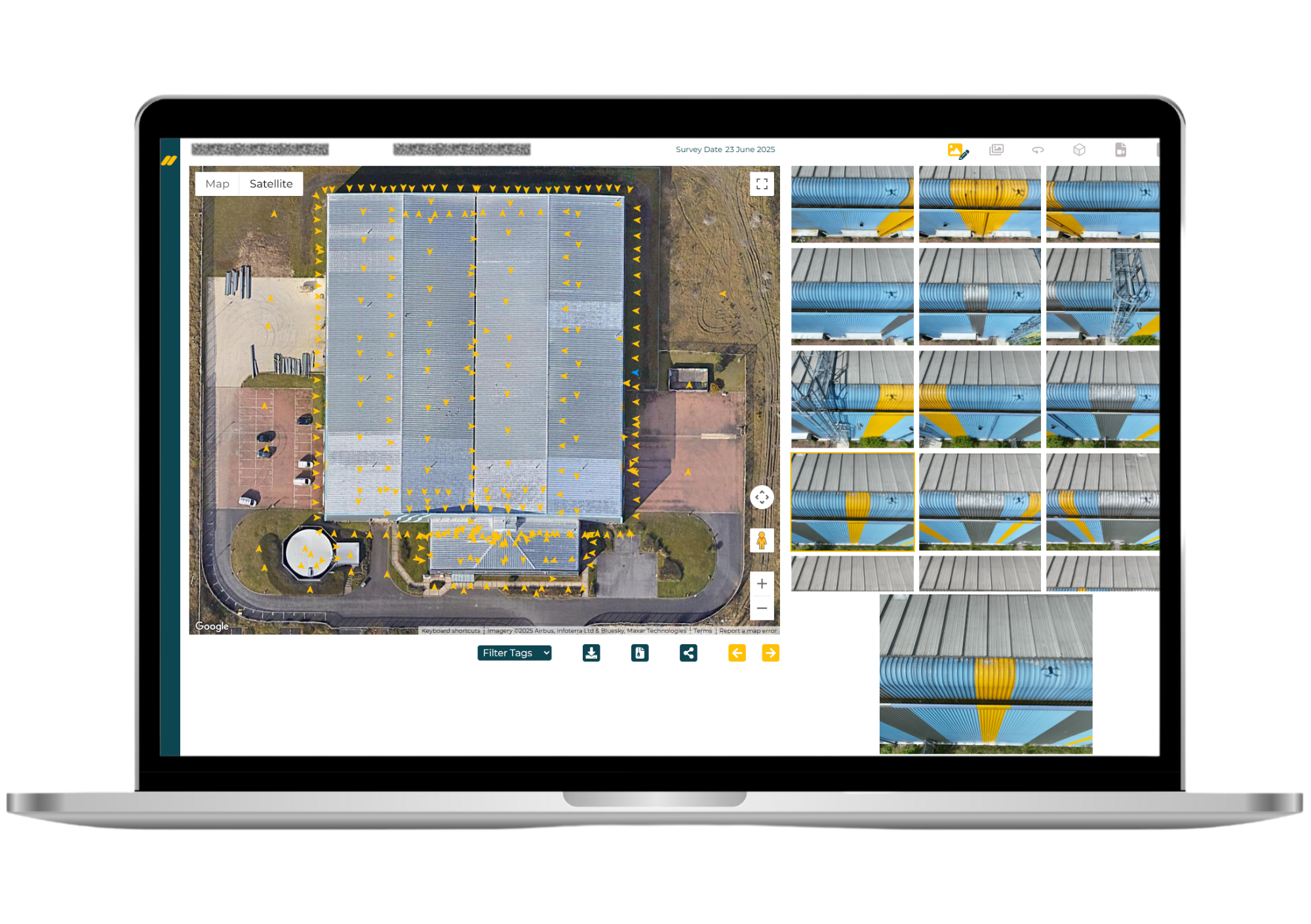
No WeTransfer links, no photo dumps. Every Norelo drone survey is delivered through your secure client portal, browse imagery by location, review defects, explore 3D models and download everything from any browser.
Drone inspection in Glasgow
Few UK cities suit drone inspection like Glasgow. The city holds one of the largest concentrations of pre-1919 sandstone tenements in Britain, alongside a Victorian commercial core, post-war estates and a modern high-rise skyline, and almost all of it hides its problems at roof level. For the factors, building surveyors, housing associations and insurers who look after that stock, drone inspection has become the first move before any money is spent on access.
Tenement roofs are the classic case: slate coverings, chimneyheads, skews, parapets and rear elevations that traditionally required scaffolding a shared close, and dividing the bill among owners, just to look. A drone inspection captures every slope and stack in a morning, giving factors and owners the evidence to scope common repairs before committing to them.
The west of Scotland’s weather does the rest. Some of the highest rainfall of any UK city region, Atlantic storms and repeated freeze-thaw cycles work relentlessly on slate, flashings, mortar joints and sandstone, which is why regular, affordable high-level inspection has moved to the centre of planned maintenance across the city.
Flying here takes local knowledge too: much of the west of the city sits within the Glasgow Airport flight restriction zone, the centre is a congested urban environment, and the city’s numerous conservation areas demand a careful, non-contact approach. Norelo’s CAA Operational Authorisation and permission handling cover all of it, and because we’re based at Royal Crescent in the west end, mobilisation across Glasgow, Paisley, East Kilbride, Hamilton, Clydebank and the wider west of Scotland is measured in days, not weeks.
Need a drone roof inspection in Glasgow? Tell us the building and the postcode, we’re already in the neighbourhood.
Good to know
How much does a drone roof inspection cost in Glasgow?
Considerably less than scaffolding a tenement or putting a MEWP on a city street, and because we’re based in Glasgow, there are no travel or mobilisation premiums. Pricing depends on the building, coverage and reporting level; send us the address and we’ll return a fixed, itemised quote, usually within one working day. See our pricing approach.
Can you fly drones near Glasgow Airport?
Yes, in most cases. Much of the west of the city sits inside the Glasgow Airport flight restriction zone, and other parts of the city carry their own constraints. We identify the airspace during planning and obtain the necessary approvals under our CAA Operational Authorisation, it’s handled by us as part of the job.
Do you inspect tenement roofs and chimneyheads?
Constantly, Glasgow’s four-storey sandstone tenements are exactly what drone inspection was made for. Slate coverings, chimneyheads, skews, parapets and rear elevations are captured in full without scaffolding the close, ideal for common repairs, factor-commissioned condition checks and giving owners clear evidence before sharing costs.
Can you inspect listed buildings and conservation areas?
Yes. Drone inspection is entirely non-contact, which makes it ideal for listed buildings and Glasgow’s many conservation areas, high-level sandstone, carved detail, spires and parapets recorded in sub-millimetre detail with nothing touching the fabric. See our heritage & conservation work.
How quickly can you attend a building in Glasgow?
Fast, we’re based at Royal Crescent in the west end. Subject to airspace permissions and weather, inspections across the city can typically be mobilised within days, and urgent post-storm or insurance captures are prioritised.
Do you cover the areas around Glasgow?
Yes, the whole of Greater Glasgow and the west of Scotland, including Paisley, East Kilbride, Hamilton, Motherwell, Clydebank and Dumbarton. We operate UK-wide, but Glasgow and the surrounding towns are home turf.
Are your drone pilots CAA approved?
Yes. Norelo holds a CAA Operational Authorisation and our remote pilots are qualified and current. Every operation is flown under documented procedures with site-specific risk assessments and method statements (RAMS) issued in advance, ready for your H&S file.
Can a drone inspection replace a surveyor’s inspection?
It’s designed to inform one, not replace it. We provide the full-coverage, close-up visual evidence; you (or your appointed surveyor or engineer) make the professional assessment. Many Glasgow building surveyors and factors use us as their eyes at height, we also work white-label through our practice-to-practice service.
What do I actually receive after a drone inspection?
An annotated PDF report with colour-coded overviews locating every image, the full geolocated 4K image set and video, and, where your assessment needs dimensions, scaled orthophoto elevations, defect location plans in DWG and 3D context models. Everything is delivered through your secure Norelo portal.
What weather can drones fly in?
We fly within manufacturer and safety limits for wind and precipitation, a real consideration in the west of Scotland, and monitor forecasts closely before capture. Being local means a re-arranged visit costs nothing in travel and happens quickly.
Book a drone inspection in Glasgow
Tell us the building or structure, anywhere in Glasgow or the west of Scotland, and we’ll confirm feasibility, permissions and a fixed quote, usually within one working day.
- 0141 353 9557
- info@norelo.uk
- 16 Royal Crescent, Glasgow, G3 7SL
- CAA-approved · SafeContractor · Cyber Essentials